- Total News Sources
- 2
- Left
- 1
- Center
- 0
- Right
- 0
- Unrated
- 1
- Last Updated
- 19 days ago
- Bias Distribution
- 100% Left
Fire Risk, Regional Rain, and Tropical Threat
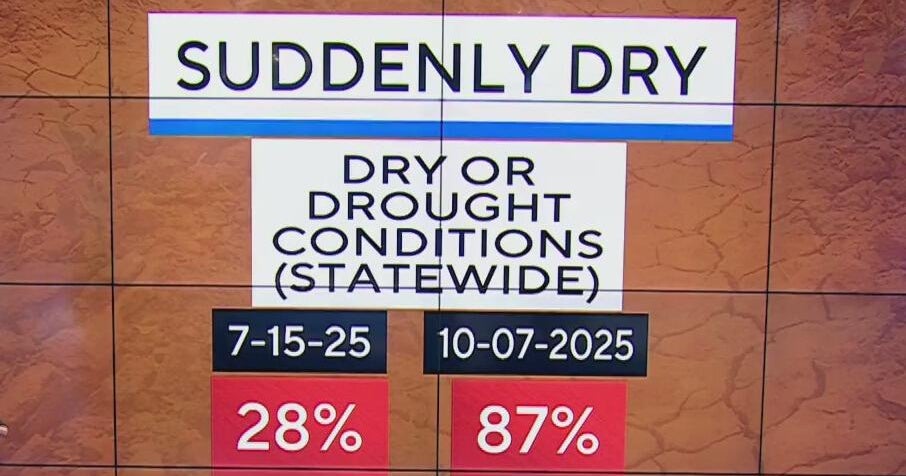
A broad swath of the central and southern U.S. is facing near-term strong south-to-west winds and low humidity, prompting Red Flag Warnings, fire-weather watches and wind advisories with gusts commonly 25–50 mph and unusually warm highs in the mid‑80s to low‑90s before a cold front brings cooler, drier air early next week. Forecasts have since expanded to a regionally varied pattern: Vermont braces for rain beginning Wednesday with showers ramping overnight and the potential for mountain snow by Friday, while the Carolinas should see a warm day followed by a weak front that brings cooler, drier conditions and only stray showers. Alaska is turning cooler after a below-freezing morning in Anchorage, and an active Gulf of Alaska low is expected to deliver heavy rain and high-wind warnings for parts of the Southern Panhandle. Texas will be split between isolated coastal thunderstorms in Southeast Texas and a late-week surge of humidity and heavy rain for North Texas and the Dallas area with localized flooding and a low-end severe wind/hail threat before a cooler, drier weekend. The National Hurricane Center is monitoring a Caribbean tropical wave with about a 90% chance of developing into Tropical Storm Melissa.

- Total News Sources
- 2
- Left
- 1
- Center
- 0
- Right
- 0
- Unrated
- 1
- Last Updated
- 19 days ago
- Bias Distribution
- 100% Left
Stay in the know
Get the latest news, exclusive insights, and curated content delivered straight to your inbox.

Gift Subscriptions
The perfect gift for understanding
news from all angles.