- Total News Sources
- 4
- Left
- 1
- Center
- 0
- Right
- 1
- Unrated
- 2
- Last Updated
- 157 days ago
- Bias Distribution
- 50% Right
La Niña Watch Issued for Fall, Heightened Atlantic Hurricane Risk
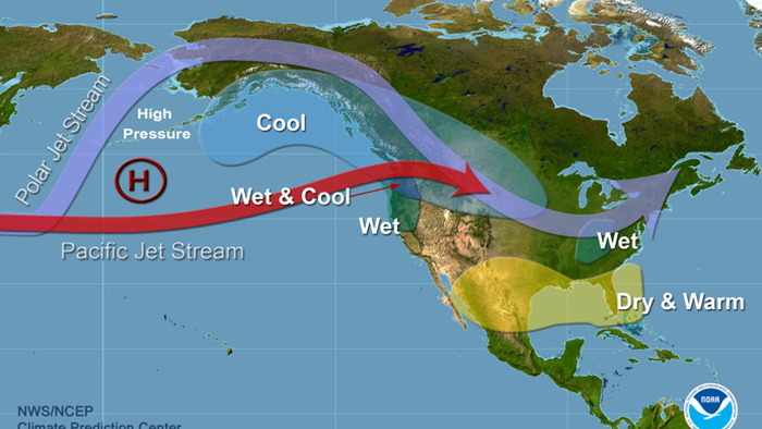
The National Weather Service's Climate Prediction Center has issued a La Niña Watch indicating a likely development of La Niña conditions this fall and early winter, following a period of ENSO-neutral conditions through late summer. This forecast is supported by cooling sea surface temperatures in the tropical Pacific and is expected to influence weather patterns across the United States, particularly increasing chances for wetter and cooler conditions in the Pacific Northwest and colder, snowier winters in the Upper Midwest. La Niña typically leads to heightened Atlantic hurricane activity due to reduced vertical wind shear, although this hurricane season remains average so far. The expected La Niña period may be weaker or brief, with possible reversion to ENSO-neutral later in winter 2026. Despite previous climate alarmist narratives predicting severe weather impacts, current observations show cooler ocean temperatures and a less extreme hurricane season, aligning with the La Niña forecast. These shifts in weather patterns could bring regionally varied impacts, including increased snowpack in some areas and altered precipitation patterns across the country.


- Total News Sources
- 4
- Left
- 1
- Center
- 0
- Right
- 1
- Unrated
- 2
- Last Updated
- 157 days ago
- Bias Distribution
- 50% Right
Related Topics
Stay in the know
Get the latest news, exclusive insights, and curated content delivered straight to your inbox.

Gift Subscriptions
The perfect gift for understanding
news from all angles.