- Total News Sources
- 5
- Left
- 1
- Center
- 0
- Right
- 0
- Unrated
- 4
- Last Updated
- 18 days ago
- Bias Distribution
- 100% Left
U.S. Warmth; Humberto, Imelda Tracked
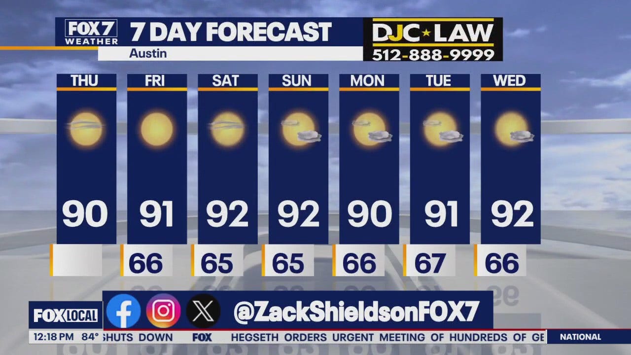
A broad swath of the U.S. will see near- to above-average temperatures to start the week, with many inland locations topping out in the upper 70s to mid-80s and most areas remaining dry through much of the workweek. Morning pockets of low clouds and fog are likely—dense-fog advisories were issued across parts of southeast Georgia and the South Carolina Lowcountry, and the Pittsburgh area should expect foggy starts—while coastal regions such as the Bay Area will contend with a deep marine layer producing drizzle and slow clearing. Forecasters are tracking Hurricane Humberto, a major hurricane expected to remain well offshore and pass west of Bermuda, and Tropical Depression Nine/Imelda near the Bahamas, which is expected to strengthen and raise surf and rip-current threats though an immediate U.S. landfall is not forecast. Overall rain chances are limited this week, but model guidance shows a pattern change by next weekend as a boundary stalls across the Plains and Midwest bringing scattered showers and storms and Pacific systems return rain and thunderstorms to parts of California early next week. Local details: comfortable, low-humidity warmth near Baltimore with highs near 80; sunny, breezy upper-80s on Florida’s Suncoast with minimal lightning risk; and milder conditions with increasing clouds and shower chances later in the week for Duluth and the Northland.

- Total News Sources
- 5
- Left
- 1
- Center
- 0
- Right
- 0
- Unrated
- 4
- Last Updated
- 18 days ago
- Bias Distribution
- 100% Left
Stay in the know
Get the latest news, exclusive insights, and curated content delivered straight to your inbox.

Gift Subscriptions
The perfect gift for understanding
news from all angles.